Posts By: galvin
Award: Indian Island County Park Living Shoreline Project
D&B received top accolades from The American Council of Engineering Companies of New York (ACEC NY) in Category G: Water Resources for its Indian Island County Park Living Shoreline Project, which was designed to provide protection, resiliency and stabilization to Indian Island’s bluff, shoreline and marshlands which were subject to chronic erosion that threatened the area’s infrastructure and navigation, coastal ecosystem and sensitive archeological/cultural artifacts.
The Indian Island County Park Living Shoreline Project was designed to provide protection, resiliency and stabilization to Indian Island’s bluff, shoreline and marshlands which were subject to chronic erosion that threatened the area’s infrastructure and navigation, coastal ecosystem and sensitive archeological/cultural artifacts. Indian Island County Park is a 275-acre park located in Riverhead (NY) at the mouth of the Peconic River, offering year-round recreation including camping, fishing, hiking, picnicking and shoreline activities. Shoreline protection and erosion control were accomplished via the creation of a Living Shoreline using natural and nature-based features, including strategic placement of living segmented emergent rock sills and marsh habitat restoration/enhancement. The project was completed on time and within budget in early 2024, overcoming unique archeological challenges and delivering multiple environmental, economic, social and cultural benefits.
The creation of a Living Shoreline is an innovative technique on Long Island which has not previously been applied in an area containing sensitive artifacts such as those in Indian Island’s ancient tribal burial ground. Whereas traditional shoreline hardening structures require extensive excavation, this environmentally sustainable alternative used minimally invasive techniques to avoid disturbing sensitive ecological habitats and archeological resources.
The successful completion of this project is an example for engineering professionals that Living Shorelines are an economically viable, environmentally friendly and a more effective way to protect shorelines than traditionally used hardening structures such as bulkhead, seawalls and jetties. The area roadway is no longer on the verge of collapsing, and the public is now able to enjoy a previously inaccessible beach area due to the installation of a new timber walkway, viewpoint and staircase.
The Living Shoreline protects vital cultural artifacts and prevents the need for future beach sand replenishment and dredging of the adjacent creek, providing historic benefits to the Native American tribes and economic benefits to Suffolk County. The marsh habitat restoration provides increased stability and resiliency to the shoreline to reduce loss, improve progression of the marsh, and sustain the vital native marsh habitat and ecosystem of the region.
The coordination between multiple government agencies and two Native American tribes in developing a solution to protect the area’s natural ecosystem while preserving cultural artifacts represented a major undertaking. For months, several tons of sand, granite, vegetation and oysters were hauled into Indian Island and strategically graded, planted and placed to build a rock sill solid enough to withstand decades of wave and tidal action.
A design benefit of the living rock sills is limitation of the expense and resources involved with dredging of the adjacent navigation channel by entrapping sand. The sills themselves provide productive rocky subaqueous marine habitat for finfish, shellfish, marine invertebrates, seaweeds, etc. Furthermore, the living rock sills have been seeded with oysters that improve water quality through their filter feeding.
(This story was originally posted at https://www.db-eng.com/)
Award: Ocean Beach Flood Mitigation and Resiliency Project
D&B received top accolades from The American Council of Engineering Companies of New York (ACEC NY) in Category F: Waste and Storm Water for its Ocean Beach Flood Mitigation and Resiliency Project which upgraded the sanitary and stormwater infrastructure within the downtown area of the Village of Ocean Beach.
The Ocean Beach Flood Mitigation and Resiliency Project was designed to upgrade the sanitary and stormwater infrastructure within the downtown area of the Village of Ocean Beach. Located on the barrier island of Fire Island (NY), this popular summer vacation community was experiencing increasingly severe flooding and groundwater infiltration of both the existing sanitary and stormwater collection systems. Project improvements included the replacement and expansion of the stormwater collection system, partial replacement of the sanitary collection system, new stormwater treatment units, and construction of a below-grade stormwater pump station to reduce downtown flooding conditions. Despite multiple logistical and scheduling challenges, construction was successfully completed on time and on budget in July 2024, bringing environmental, economic and quality of life benefits to residents, business owners and visitors of Ocean Beach.
Multiple innovative construction techniques were utilized, particularly due to extremely high groundwater levels and the need to consolidate a variety of disparate systems. Flood mitigation and resiliency were accomplished via a new watertight stormwater collection system able to account for high groundwater conditions and a sophisticated 10-million-gpd stormwater pump station.
This project demonstrates that stormwater pump stations are an economically viable way to vastly improve living conditions in bayfront communities confronting sea level rise. The elimination of hazardous flooding has had positive environmental, economic and quality of life impacts, increasing home values and enabling business continuity. Previously untreated stormwater runoff is now filtered before discharge into the Great South Bay, and groundwater infiltration into the sanitary sewer system has been eliminated. As an added public benefit, the recreation area was upgraded after being used as a staging site.
The removal of groundwater infiltration into the sanitary collection system results in additional capacity at the sewage treatment plant and puts Ocean Beach in the position to reduce the number of cesspools on Fire Island by expanding its sewer district into neighboring communities. New stormwater treatment units provide water quality improvements through the removal of sediment and pollutants prior to discharge into the bay.
Since Fire Island is accessible primarily by boat, all construction equipment and materials had to be transported from the mainland via ferry or barge. The large influx of summer tourism meant all work had to be performed during the nine-month off-season. Additionally, the pump station required substantial support of excavation efforts to account for poor soil conditions and excavation depths up to 30 feet.
The use of the Village’s recreation area as the project staging site had a beneficial outcome, as residents are enjoying upgrades to the facilities including new tennis, pickleball and basketball courts. Downtown businesses were improved with reconstructed entrances that were raised to promote drainage, and vegetation at the surface of stormwater treatment units added beautification while removing stormwater pollutants.
(This story was originally posted at https://www.db-eng.com/)
‘Living’ shorelines help guard Long Island coast against ravages of storms
Living shorelines use natural elements and sometimes structural components to control erosion.
Click link below for full article!
https://www.newsday.com/long-island/environment/living-shoreline-uma1mj5o
Jamaica Bay – Rockaway Parks Conservancy – West Pond Living Shoreline Restoration Project
Project Overview
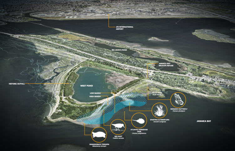
In May 2019, the Jamaica Bay-Rockaway Parks Conservancy (JBRPC) contracted with Dirtworks Landscape Architecture, PC to finalize design of a living shoreline at West Pond in the Jamaica Bay Wildlife Refuge, Gateway National Recreation Area, in partnership with the National Park Service (NPS). Final design was completed in July 2020 and permitted for construction in 2021.
As a living shoreline, the restoration project uses natural features to protect West Pond and adjacent loop trail, limiting erosion along this vulnerable shoreline while enhancing the shoreline with native plants creating much needed habitat in Jamaica Bay. During design, JBRPC worked in close collaboration with community stakeholders, including the Jamaica Bay Ecowatchers and American Littoral Society, and other project partners such as the Billion Oyster Project. Construction began in May 2021 and was completed in November 2021. Read more here.
Rockaway Wave: Wetland Restoration (August 6, 2021)
PROJECT FACTS
- 2,400 linear feet of shoreline restored with 51,000 cubic yards of sediment
- 9+ acres of habitat created and 14-acres of habitat restored
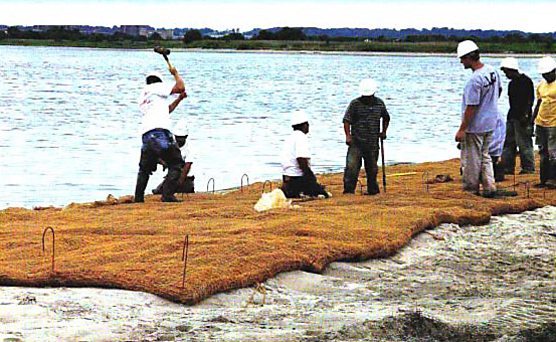
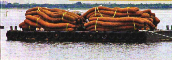
- 5,000 biodegradable shell-bag breakwater structures creating a system of breakwaters to attenuate wave energy and protect the edge
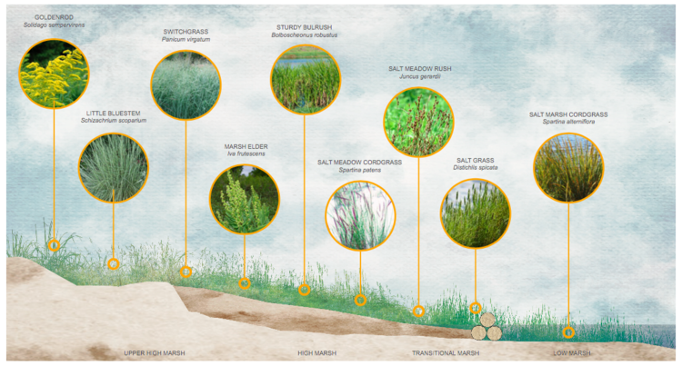
- 200,000 native grasses and shrubs planted
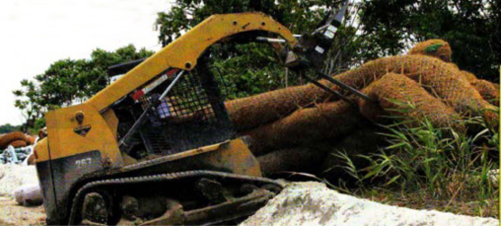
- 100 fascines (recycled trees) to stabilize the shoreline
- 15 coir logs to stabilize the shoreline and limit erosion
- Historic outfall on the north end of West Pond reconstructed and repaired
Original Source: http://www.jbrpc.org/westpond
The Latest Addition to Galvin Bros., Inc. – Remu Big Float E22
We’ve been working hard on the Canaan Lake Restoration Project using the Big Float E22 Amphibious Excavator. Canaan Lake is a 26 acre lake in Long Island, NY that has been affected by many different invasive plant species, making the lake essentially unusable to the public and the residents who own homes around the lake. The Big Float E22 was brought in to dredge the lake and pile the dredged material on the shoreline to dry out and then be hauled away. (description and images courtesy of Remu)
Galvin Corps Restore New York City Wetlands
$13-Million Elder’s Island Project Helps Stem Jamaica Bay Salt Marsh Loss
Story By Matthew Phair, July 2, 2007, Constructioneer
 In the skyline of one of the most populated, urban areas of the world adjacent to one of the nation’s busiest airports, Elders Point Island in Jamaica Bay Gateway National Park, King’s County, N.Y., is the focus of an impressive marsh island restoration project. The first phase of construction is underway on a $13-million wetland restoration project. It is also the first full-scale project to address the marsh island recession issue in Jamaica Bay.
In March 2006, the corps awarded a $13-million contract for the Elders Point (East) Island Restoration in Jamaica Bay, N.Y., to Galvin Brothers of Great Neck, N.Y. To re-contour Elders Island, the corps is pumping more than 300,000 cubic yards of sand that was dredged from various channels in the harbor. Once tidal flow to the areas has been reestablished, water and sediment quality will be improved, promoting the return of native fish and wildlife.
“Working with our partners, this project is the first step towards the long and complex journey of addressing the salt marsh loss within Jamaica Bay. During the first phase, more than $13 million of construction activity to restore the environment at this site will provide 70 acres of wetlands for our harbor estuary,” said Col. Richard J. Polo, Jr., New York district engineer. “This will be the first large scale marsh island restored, building on the Big Egg pilot, under the District’s Jamaica Bay Marsh Islands Ecosystem Restoration Program.”
 In total, approximately 70 acres of marsh will be restored on Elders Point with a net increase of 61 acres. Elders Point is comprised of two separate islands, Elders Point East and Elders Point West, that total approximately 21 vegetated acres. Originally one island comprised approximately 132 acres; the loss of marsh in the center portion severed the two ends, resulting in two separate islands connected by mudflat. The restoration plan for Elders East and Elders West includes restoring the existing vegetated areas and the sheltered and exposed mudflats by placing fill material up to an elevation that is suitable for low marsh growth. This includes hand-planting more than 700,000 plants on Elders East and replanting more than 200,000 plants on Elders West.
Jamaica Bay is one of the largest areas of open space in New York City and contributes significantly to the overall health of the New York and New Jersey Harbor Estuary. The marsh islands ecosystem is an integral part of Jamaica Bay and is a refuge for a variety of wildlife. It also provides valuable habitat for fish species as well as a nursery for juvenile, migratory birds.
 The Marsh Islands ecosystem is an integral part of Jamaica Bay, which has been targeted for restoration by the U.S. Army Corps of Engineers and other New York and national agencies. Jamaica Bay is recognized by the United States Fish and Wildlife as a coastal habitat deserving preservation and restoration of habitats, which contribute to sustaining and expanding the region’s native living resources. These species breed and use the area as a nursery for juvenile, migratory birds that reside in the area during winter and migratory birds that stop-over in the area during fall and spring migrations.
The overall program includes wetlands work in Staten Island and Jamaica Bay, N.Y., and Carteret and Woodbridge, N.J. Nearly 80 percent of the Hudson-Raritan Estuary’s (at 42,000 square miles it is one of the largest in the east coast) tidal salt marshes have been lost and even less of its 224,000 acres of freshwater wetlands remain.
 The NYSDEC estimates that approximately 1,400 acres of tidal salt marsh have been lost from the marsh islands alone since 1924, with the system-wide rate of loss rapidly increasing in recent years. Between 1994 and 1999, an estimated 220 acres of salt marsh were lost at an alarming rate of 44 acres per year (NPS, 2001). Further, it is estimated if this trend continues, all remaining salt marsh on the islands will be lost over the next three decades.
The ongoing $27-million environmental mitigation program in the Hudson Raritan Estuary is being implemented in conjunction with the $1.6-billion New York and New Jersey Harbor Deepening Project. More than 1.5 million plants will be planted throughout the region.